UFO in Jerusalem

Gelsons Dad said:
If a UFO bobbed up and down over one of the most significant religious sites in the world why is there only one crap video from two angles when everyone has a camera on their phone?
Simple answer.
Because people nowadays are too fucking busy staring at their phones to bother even to look forward let alone look upwards.
 
-dabz- said:
Gelsons Dad said:
If a UFO bobbed up and down over one of the most significant religious sites in the world why is there only one crap video from two angles when everyone has a camera on their phone?
Simple answer.
Because people nowadays are too fucking busy staring at their phones to bother even to look forward let alone look upwards.

Oh yes, forwardforwardforward, phone needs charging, i'm gonna be late, whats he looking at? debtdebtdebt, can't afford to live, don't wanna live, get to the sunbed shop, get to the gym, recession, car needs taxing/mot, mortgage, don't eat this/that, food to dear, tory bastards/labours great,.tories are the best/labour scum, money-christmas/valentines/easter/halloween/bommie night/christmas,moneymoneymoney,city,snoopers/grasses, two week in spain, muslim bombers, flyings dangerous,peados everywhere in every street, bagrats,traffic wardens AAARRRGGGGGHHHHHHHHHHHHHH.

Deep breaths and mmmmmmmmmmmmmm,nice.
 
buzzer1 said:
Gelsons Dad said:
If a UFO bobbed up and down over one of the most significant religious sites in the world why is there only one crap video from two angles when everyone has a camera on their phone?

Ah there you are Gelse, mornin'. Now completely off thread but could you tell me why the sky looks like a slashed up canvas with thick white lines and somedays it is'nt? i have monitored certain days over a 4 week period and there is the same plane activity but with seemingly different skies? and most definately the day after the trails, it is overcast? Whats your thoughts?

Yes.

The white lines are condensation trails or "con trails" the conditions required to create the trails are a quite narrow range of temperature and humidity. In the right conditions the trails will be formed by the water vapour from the engine exhaust adding to the water content in the atmosphere and pushing the value over the local saturation point. The saturation point changes with temperature and pressure. However the atmosphere isn't constant. There is a standard model called the international Standard Atmosphere or ISA and in aviation we refer to temperature (and therefore density altitude) with reference to ISA. So I may look at my Outside Air Temperature at 30,000ft and see that it's -45C this would be about standard. It would equate to a sea level temperature of +15.However, it's not unusual to find yourself in ISA -10 or ISA + 10 at medium altitudes (below the tropopause). This not only effects the performance of the engines but also along with the humidity whether or not con trails are formed and how long they last. As the altitudes that the aircraft fly are pretty standard then on some days at those altitudes the right conditions will exist and on others they wont. Hence some days lots of trails which last for hours and other days none.

I've flow across the atlantic following another aircrafts trail all the way and on other days seen none. Some times they last for hours and other times they brake up quickly. Some times they can form into a row of doughnuts which looks cool
 
Gelsons Dad said:
buzzer1 said:
Ah there you are Gelse, mornin'. Now completely off thread but could you tell me why the sky looks like a slashed up canvas with thick white lines and somedays it is'nt? i have monitored certain days over a 4 week period and there is the same plane activity but with seemingly different skies? and most definately the day after the trails, it is overcast? Whats your thoughts?

Yes.

The white lines are condensation trails or "con trails" the conditions required to create the trails are a quite narrow range of temperature and humidity. In the right conditions the trails will be formed by the water vapour from the engine exhaust adding to the water content in the atmosphere and pushing the value over the local saturation point. The saturation point changes with temperature and pressure. However the atmosphere isn't constant. There is a standard model called the international Standard Atmosphere or ISA and in aviation we refer to temperature (and therefore density altitude) with reference to ISA. So I may look at my Outside Air Temperature at 30,000ft and see that it's -45C this would be about standard. It would equate to a sea level temperature of +15.However, it's not unusual to find yourself in ISA -10 or ISA + 10 at medium altitudes (below the tropopause). This not only effects the performance of the engines but also along with the humidity whether or not con trails are formed and how long they last. As the altitudes that the aircraft fly are pretty standard then on some days at those altitudes the right conditions will exist and on others they wont. Hence some days lots of trails which last for hours and other days none.

I've flow across the atlantic following another aircrafts trail all the way and on other days seen none. Some times they last for hours and other times they brake up quickly. Some times they can form into a row of doughnuts which looks cool

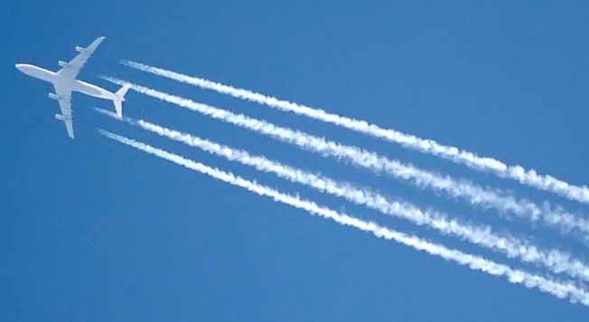
So the lines are down to atmospheric pressure? and they are all con trails?
 
rickmcfc said:
Just one thing i have noticed which may prove its a hoax, in the first video the object is still and hovering over the church for 21.9 seconds. In the second video it is only hovering for 3.7 seconds, thats quite a difference!!!

Its bollocks.


lol....it's because the second vid has been edited by the itn production team rather than show the full 20 odd seconds on the second vid clip

you can see the point the second vid is clipped down
 
buzzer1 said:
Gelsons Dad said:
Yes.

The white lines are condensation trails or "con trails" the conditions required to create the trails are a quite narrow range of temperature and humidity. In the right conditions the trails will be formed by the water vapour from the engine exhaust adding to the water content in the atmosphere and pushing the value over the local saturation point. The saturation point changes with temperature and pressure. However the atmosphere isn't constant. There is a standard model called the international Standard Atmosphere or ISA and in aviation we refer to temperature (and therefore density altitude) with reference to ISA. So I may look at my Outside Air Temperature at 30,000ft and see that it's -45C this would be about standard. It would equate to a sea level temperature of +15.However, it's not unusual to find yourself in ISA -10 or ISA + 10 at medium altitudes (below the tropopause). This not only effects the performance of the engines but also along with the humidity whether or not con trails are formed and how long they last. As the altitudes that the aircraft fly are pretty standard then on some days at those altitudes the right conditions will exist and on others they wont. Hence some days lots of trails which last for hours and other days none.

I've flow across the atlantic following another aircrafts trail all the way and on other days seen none. Some times they last for hours and other times they brake up quickly. Some times they can form into a row of doughnuts which looks cool


So the lines are down to atmospheric pressure? and they are all con trails?

its all down to relative dew points and suturation points as gelson says ;)
 
buzzer1 said:
Gelsons Dad said:
Yes.

The white lines are condensation trails or "con trails" the conditions required to create the trails are a quite narrow range of temperature and humidity. In the right conditions the trails will be formed by the water vapour from the engine exhaust adding to the water content in the atmosphere and pushing the value over the local saturation point. The saturation point changes with temperature and pressure. However the atmosphere isn't constant. There is a standard model called the international Standard Atmosphere or ISA and in aviation we refer to temperature (and therefore density altitude) with reference to ISA. So I may look at my Outside Air Temperature at 30,000ft and see that it's -45C this would be about standard. It would equate to a sea level temperature of +15.However, it's not unusual to find yourself in ISA -10 or ISA + 10 at medium altitudes (below the tropopause). This not only effects the performance of the engines but also along with the humidity whether or not con trails are formed and how long they last. As the altitudes that the aircraft fly are pretty standard then on some days at those altitudes the right conditions will exist and on others they wont. Hence some days lots of trails which last for hours and other days none.

I've flow across the atlantic following another aircrafts trail all the way and on other days seen none. Some times they last for hours and other times they brake up quickly. Some times they can form into a row of doughnuts which looks cool


So the lines are down to atmospheric pressure? and they are all con trails?

They are contrails.
contrail607.jpg


The main byproducts of hydrocarbon fuel combustion are carbon dioxide and water vapor. At high altitudes this water vapour emerges into a cold environment, and the local increase in water vapor can push the water content of the air past saturation point. The vapour then condenses into tiny water droplets and/or deposits into ice. These millions of tiny water droplets and/or ice crystals form the vapour trail or contrails. The vapor's need to condense accounts for the contrail forming some way behind the aircraft's engines. At high altitudes, supercooled water vapor requires a trigger to encourage deposition or condensation. The exhaust particles in the aircraft's exhaust act as this trigger, causing the trapped vapor to rapidly turn to ice crystals. Exhaust vapour trails or contrails usually occur above 8000 metres (26,000 feet), and only if the temperature there is below −40 °C (−40 °F).[3]

<a class="postlink" href="http://www.es.lancs.ac.uk/hazelrigg/amy/Photos/DSCF0032.JPG" onclick="window.open(this.href);return false;">http://www.es.lancs.ac.uk/hazelrigg/amy ... CF0032.JPG</a>

contrails317140916_std1.jpg
 
BulgarianPride said:
buzzer1 said:
So the lines are down to atmospheric pressure? and they are all con trails?

They are contrails.
contrail607.jpg


The main byproducts of hydrocarbon fuel combustion are carbon dioxide and water vapor. At high altitudes this water vapour emerges into a cold environment, and the local increase in water vapor can push the water content of the air past saturation point. The vapour then condenses into tiny water droplets and/or deposits into ice. These millions of tiny water droplets and/or ice crystals form the vapour trail or contrails. The vapor's need to condense accounts for the contrail forming some way behind the aircraft's engines. At high altitudes, supercooled water vapor requires a trigger to encourage deposition or condensation. The exhaust particles in the aircraft's exhaust act as this trigger, causing the trapped vapor to rapidly turn to ice crystals. Exhaust vapour trails or contrails usually occur above 8000 metres (26,000 feet), and only if the temperature there is below −40 °C (−40 °F).[3]

<a class="postlink" href="http://www.es.lancs.ac.uk/hazelrigg/amy/Photos/DSCF0032.JPG" onclick="window.open(this.href);return false;">http://www.es.lancs.ac.uk/hazelrigg/amy ... CF0032.JPG</a>

contrails317140916_std1.jpg

That's what I said!
 

Don't have an account? Register now and see fewer ads!

SIGN UP
Back
Top
  AdBlock Detected
Bluemoon relies on advertising to pay our hosting fees. Please support the site by disabling your ad blocking software to help keep the forum sustainable. Thanks.