Middle East Conflict (merged) | Iran launch missile attack after Israel invade Lebanon

Therefore in literal terms it's disproportionate to shoot someone who can't shoot back.
No it fucking isn’t. Knives can do just as much damage close up and tasers are 100% and I’ve seen enough videos of big blokes and others high on drugs not being deterred by their use.

What you’re trying to do is downplay the needless massacre by the Israelis by saying we are just as bad.
 
You know which one Einstein was referring to.


Highly contested opinion if you read on the extensive commentary against McGraw-Hill. Renowned cartographers also support the four maps as an informative illustration on land possession.


A few points here since you brought up absentee landlords. The whole region of Israel and Gaza, West Bank amount to 28,092 km2. From and up to 1944, Israeli has bought a total of 906.80 km2 of land. Of these, 25% were sold by Palestine Arabs, and 52% were sold under the nuance of absentee landlords. Two things:

1. The fact that 25% of the land bought were Palestinian owned imply that Palestinians do own a sizeable portion of the land area. In fact, the United Nations Conciliation Commissions for Palestine has a record of not less than 530,000 land ownership records owned by Palestinians. Here is a detailed map of land ownership in Palestine.

16


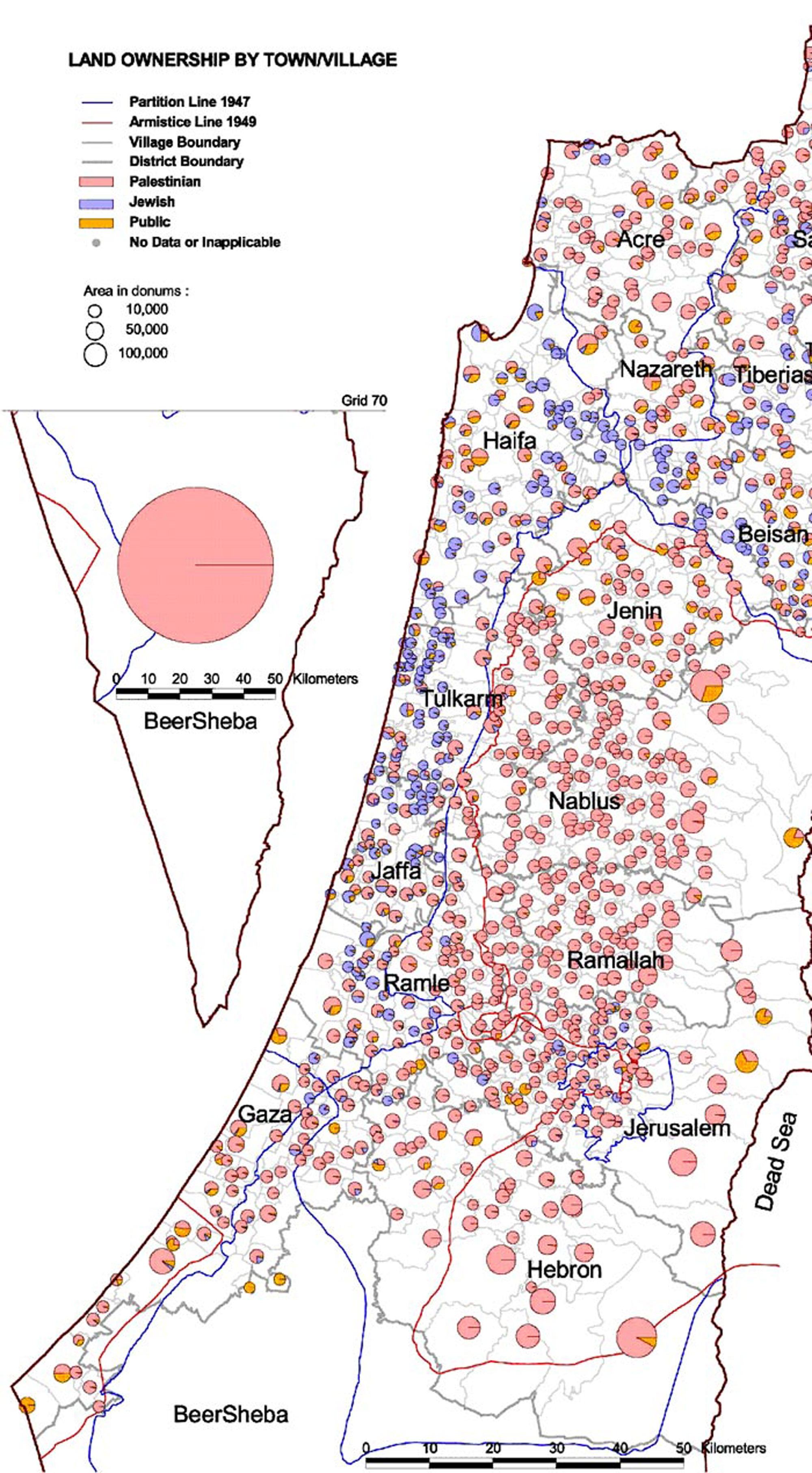
2. Despite the ownership being recorded by UNCCP, I feel you may still want to argue that the 52% non Palestinian owned land were owned by absentee landlords. Now, The absentee landlords lands were not bought but rather appropriated in a clever way that, playing devil's advocate, because there is a lack of documentation recorded by UNCCP, the land is declared owned by an 'absentee landlord'. A special hearing was made in 1930s by MK Tichon, Orok and several other MKs questioning how land is concluded as having an absentee landlord. The inquest found that because the land was not declared, the mukhtar of the town/village, in exchange for money, can produce an affidavit out of thin air that the land can be bought from the mukhtar based on it being owned by an 'absentee landlord'. As how you allude to the idea that Negev desert was not owned by anyone, these lands were actually not owned by any absentee landlord, but rather either owned by a Palestinian who was oblivious his land was being sold by the mukhtar, or have no ownership thus making those who were evicted from these land the landowner in the first place based on the mandate that land with inhabitants cannot be purchased or taken. Adding to this, we also have the absentee landlords who are 'present absentees'. Present absentees are classified as Palestinians who left or were expelled from their land by Israeli forces even for a short duration of time without leaving the Israel boundary, even when the move is involuntary, they lose the legal right to their possession and their land. These Palestinians lands, their Palestinian owners driven away thus classifying them as present absentees, are also land under absentee landlords. So, you see, the usage of the term 'absentee landlord' was a convenient loophole to allow for the appropriation of land.

And on Negev, The Negev desert may not be documentedly owned by anyone, as title deeds are not compulsory registered and claims of ownership were regulated by private unregistered conveyances, but an official national census conducted on the Negev area listed more than 53,000 Bedu Palestines.

The first map is only inaccurate if you refute firstly the records of land ownership in UNCCP, secondly the revelation of the hearing on how 'absentee landlords' were declared, and thirdly the idea that many parts of the land were not owned by anyone.


See the comment on land ownership above and why it has been rejected. The two state solution however has been revisited by Palestine and preconditional to a 1948 border, with Jerusalem included and the right of return, a compromised two state solution has repeatedly been suggested by Palestinians, regardless of opinions from the Arab league.


Does this not contradict your argument? If there are still many Arab towns and villages within Israel, what do you think they were part of in the first place? There are indeed several Arab towns and villages within Israel populated by Arabs who refer themselves as Palestinians.


By this time, land ownership is no longer the humanitarian concern. What we have in the fourth map is definitely political control whereby failure to comply to stay within the designated Palestinian zones result in being killed. Which is why discussion on land ownership based on the current situation dilutes the more humanistic argument of Palestinians in Gaza crammed in 390km2 of space with more than 5000 people per square kilometre of land when divided equally, making it the 3rd most dense boundary locked area in the world like Hong Kong and Singapore. Unlike the two other countries however, Gaza doesn't have skyscrapers and high rise living, nor does it have clean water, sufficient amenities, enough food, freedom to travel, open ports, employment opportunities and the right to protest.


Doesn't mean the facts are wrong or inaccurate. They are after all, recorded and documented throughout the years.
My point remains. Irrespective of the accuracy of the individual maps (and I would say that each are misleading in their own way for reasons stated previously) the whole point of putting them together was to illustrate a supposed progressive land grab. As they are all based on completely different criteria in regard to land ownership, political control or simply a proposal for partition, they are nothing more than propaganda to influence those that haven’t looked into the situation in any detail.
 
If you haven’t watched the videos then do so and you may not look such a pillock. Doubtful though.
As usual, s much as I love you, you resort to your default position of insulting rather than debating. I've watched some but that's completely irrelevant. There was a declared exclusion zone of 300m. Anyone in that area was warned they could be shot. They weren't walking down the road, hands in pockets, whistling a merry tune on their way to the shop. They were there to provoke trouble and they got their wish.

You read the FT don't you? Did you see the Big Read piece about it the other day? I like the FT because it's informative and genuinely impartial, like the Economist. That article made it clear that this wasn't about Israel but about Hamas's role, to establish their supremacy of the PA and force Qatar into restarting the funding which they'd withdrawn while etting Egypt to open the Rafah crossing.

After reading that piece my attitude changed as it was clearly a cynical move by Hamas to ensure that the population of Gaza didn't turn on them due to their failures. So, 60 or so deaths later, they've got some breathing space. Those deaths mean as little to them as they do to Israel. If they do mean more, it's only because they advance their cause. So if I sound cynical, it's because I am.


43:30 minutes in should explain why our police shoot people wielding knives.
 
My point remains. Irrespective of the accuracy of the individual maps (and I would say that each are misleading in their own way for reasons stated previously) the whole point of putting them together was to illustrate a supposed progressive land grab. As they are all based on completely different criteria in regard to land ownership, political control or simply a proposal for partition, they are nothing more than propaganda to influence those that haven’t looked into the situation in any detail.

Well, I presented a detailed account of the situation that led to the four maps. You are basing your arguments based on the McGraw Hill paranoia that led them to withdraw the maps in the first place as it recognise ownership of land by Palestinians rather. If they were not demanded to withdraw the map and destroy all published instances of it, everyone will see the map as is, rather than a map supposedly based on propaganda, which itself has been regarded as communities worldwide being the actual propaganda.

Your arguments were below:

1. Lands were not owned by Palestinians but by absentee landlords.

My response was the term 'absentee landlords' has already been investigated by Knesset to represent land whose owner did not know they were sold by mukhtars who wrote fraudulent affidavits. And that land can be claim absentee landlord once you drive the Palestinian owner out of their land via present absentee.

Land grab strategy = appropriation of small areas of land.

2. The map of the UN Partition Plan was rejected by Arab.

everyone who read Palestine issue knows what the regardless of the plan not being enacted by the UN, the resolution of the partition plan was adopted as the boundaries by Israel, explicitly stated 3 times in the Declaration of Independence. The only difference was instead of it being enacted by the UN resolution, it was enacted by the Haganah under Plan Dalet. Read about plan Dalet and you will see how crucial the Partition Plan was in Israel's preparation to strategically place yishuvs in the areas assigned by the partition plan under Plan Alef, Bet and Gimel prior to Dalet.

Land grab strategy = referred to in Israel's declaration as the main justification for the State of Israel, regardless of it being followed through by the UN. It was a clandestine series of plans to realise the partition by the Haganah.

3. Gaza and West Bank under Egypt and Jordan.

The map expands from 1949 to 1967 of course the annexation of these parts will be part of its timeline. It's not the green parts that is the issue, it's the white parts of the map, showing areas where land has been grabbed based on the 1948 seizure of land (see above).

Land grab strategy = The partition plan being realised by the Haganah, and more.
 

Don't have an account? Register now and see fewer ads!

SIGN UP
Back
Top
  AdBlock Detected
Bluemoon relies on advertising to pay our hosting fees. Please support the site by disabling your ad blocking software to help keep the forum sustainable. Thanks.