Great Clowes St / Wenlock Way Gorton

mcfcinprague said:
http://en.wikipedia.org/wiki/Brooks_%26_Doxey

Brook & Doxey was a textile machinery manufacturer from West Gorton, Manchester in England. It was founded in 1859. It was incorporated in 1920. The company used the Union Iron Works, West Gorton. The company also had a factory in Stockport. Ferranti bought the old Union Iron Works to make mainframe computers in 1956. It later became ICT ('International' Computers & Tabulators), then ICL[disambiguation needed]. ICT grafted a ‘modern’ entrance on but kept the works.


Here's a link about the old Union site

I used to work for ICL there from 1974 to 1979 when the factory moved to Ashton


So William Beastow worked on the same bit land where you worked.

He with the Connells and a few others formed St Marks FC.

I want to get the old ICL tower renamed William Beastow tower.
 
http://www.alangodfreymaps.co.uk/lancs10416.htm
http://www.knowhere.co.uk/Gorton/Greater-Manchester/Northern-England/messages?start=5

just found this information on Clowes street remember its WEST GORTON..

I use to have a job after school on clowes street.. a motor bike shop then another job at the 3 wheeeler co just round the corner on Hyde road..


Anyway below just found referance to Elizabeth street.. that run from Hyde road through to Clowes street it was at the end of this street St Markes church was,,,

J

Re: Maps of West Gorton by Paul Hartley (Member 10226532) on 22-May-2008
Hi Brian, Did you ever find Elizabeth Street, it changed names as did quite a few of the streets around there in the early 60�s for some strange reason, and it became Elland Street. I use to go to St Mark�s �old� school from 1960 � �67 which was close to it. St Mark�s had a �new� school built in 1971 on the land where Elizabeth St use to be, that school closed about 1990 and was only demolished
around 2 years ago. Nowadays if you travel along Hyde Rd heading towards Debdale, you pass Redgate Lane junction on the right and Elizabeth St would be the ground 20 yards past this junction to the left of Hyde Rd, the other end of Elizabeth St

# e: Maps of West Gorton by John HOLMES (Member 10245597) on 26-Nov-2010
Can I settle your Elizabeth Street, West Gorton query for you?
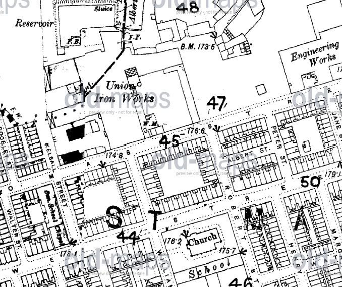
Travelling from Manchester City Centre along Hyde Road towards Denton, you would pass the end of Clowes Street on your left-hand side.
Streets after that junction were as follows:
Albert Street, East View, Kay Street, Pollitt Street, Cromwell Street, Milton Street and then the seventh street was Elizabeth Street.
It ran north from
Hyde Road and after a left-turn dog-leg at Spurgeon Street, it met Clowes street almost opposite the Baptist Chapel on the corner of Clowes Street and Kelsall Street.
Hope this helps?
John.
... more >>

# Re: Maps of West Gorton by John HOLMES (Member 10245597) on 4-Dec-2010
Paul,
It was funny seeing your reference to Elizabeth Street and the recently-demoloished St Marks' School (second version of course).
I was born at 124 Clowes Street in December 1947.
I have been able to pinpoint the exact spot using old maps, and it stood on the site of what is now a run-down cafe that sits next to the run-down Gorton Labour Club.
That club stands on the spot where the Beswi
ck Co-op (Grocers and Butchers) formerly stood, right on the junction of Clowes Street and William Street, with St Marks' Church on the next corner.
You are quite correct, Elizabeth Street met Clowes Street where the run-down (ex-Strattons) Chemists shop now stands.
It hurts me to refer to these areas as "run-down, but how dreadfully accurate the decsription is nowadays.
How I long for those peaceful days to return, but alas they are gone forever and it's all downhill for West Gorton now. Great sadness.
John.
.
 
stmarksunion.jpg

This is the 1893 map
 
I lived on Ashmore Street which was the first street that joined between Hyde Road and Redgate lane. On Ashmore Street / Hyde Road junction was the Eccles cake factory.

I think there was a church hall a few yards along towards the centre of Manchester on Hyde Road that was St Marks where there was a Sunday School (I might be wrong it's a long time ago). Opposite was the Horse Shoe pub.

Going the other way was a toy shop called Mawsons

Wenlock way was in the new housing estate over the other side of Hyde Road. There was a Primary School there with the same name.
 
Only just spotted this thread but pleased there's so much interest in it.

Today's Wenlock Way used to be called Thomas Street. They simply renamed the main part of it. If you were travelling down it from Gorton (coming from St. Francis area) some of the old buildings (to the right of '47' on the map) and the car park that was the car park for ICL/Fujitsu was the Union Ironworks/Brooks & Doxey's factory are on your right.

The car park itself was probably (though I can't conclusively prove it) the site of the St. Mark's first pitch used in 1880 (shown near '47' on the map in an earlier post). I know it was just about the only spare bit of land in the area in 1880 and that the land was used for recreation including cricket at times.

It makes sense that this piece of land was used.

Running parallel with Thomas Street was Clowes Street. Part of Clowes St still exists (starts at Hyde Rd opposite the car showroom). Pre mid 1970s that street ran in a straight line to the Gorton Brook Hotel (demolished a few years back, but the site is now on the opposite side of the ring road).

When they demolished the old terraced housing and built the 'new' estate in the mid 70s they put a curve in the road and made the significant part of Clowes St (i.e. the bit where St. Mark's was) a walk instead. That is now known as Gorton Villa Walk (ironically Gorton Villa FC were one of St. Mark's biggest rivals in the 1880s, and the walk is named after the same building as the Villa football team).

The square where the present day shops are and the WMC was the site of St. Mark's Church. There used to be a blue plaque on the Aces pub but when I looked in November it was missing.

In my book "Manchester A Football History" I talk of this area and the first ground (plus City's others) and in "Manchester The Greatest City" I include maps of the site and so on.

One significant modern day story.... the shops and Gorton Villa Walk were used as Chatsworth in the first few series of Shameless. They have since built a set, but if you pop down and have a look at the area you'll see all the buildings originally featured in Shameless (except the pub which has now been demolished - it was on the corner of Wenlock Way/Thomas St and the modern road that crosses Gorton Villa Walk to Clowes St).
 
OP, don't forget this area is West Gorton, not Gorton. Maybe change the thread title.

(Sorry for being picky!)
 
Wasn't there an engineering company Holden & Brooke in that area.I lived on St Annes St.
 
Gary James said:
Only just spotted this thread but pleased there's so much interest in it.

Today's Wenlock Way used to be called Thomas Street. They simply renamed the main part of it. If you were travelling down it from Gorton (coming from St. Francis area) some of the old buildings (to the right of '47' on the map) and the car park that was the car park for ICL/Fujitsu was the Union Ironworks/Brooks & Doxey's factory are on your right.

The car park itself was probably (though I can't conclusively prove it) the site of the St. Mark's first pitch used in 1880 (shown near '47' on the map in an earlier post). I know it was just about the only spare bit of land in the area in 1880 and that the land was used for recreation including cricket at times.

It makes sense that this piece of


Running parallel with Thomas Street was Clowes Street. Part of Clowes St still exists (starts at Hyde Rd opposite the car showroom). Pre mid 1970s that street ran in a straight line to the Gorton Brook Hotel (demolished a few years back, but the site is now on the opposite side of the ring road).

When they demolished the old terraced housing and built the 'new' estate in the mid 70s they put a curve in the road and made the significant part of Clowes St (i.e. the bit where St. Mark's was) a walk instead. That is now known as Gorton Villa Walk (ironically Gorton Villa FC were one of St. Mark's biggest rivals in the 1880s, and the walk is named after the same building as the Villa football team).

The square where the present day shops are and the WMC was the site of St. Mark's Church. There used to be a blue plaque on the Aces pub but when I looked in November it was missing.

In my book "Manchester A Football History" I talk of this area and the first ground (plus City's others) and in "Manchester The Greatest City" I include maps of the site and so on.

One significant modern day story.... the shops and Gorton Villa Walk were used as Chatsworth in the first few series of Shameless. They have since built a set, but if you pop down and have a look at the area you'll see all the buildings originally featured in Shameless (except the pub which has now been demolished - it was on the corner of Wenlock Way/Thomas St and the modern road that crosses Gorton Villa Walk to Clowes St).


Another interesting contribution Gary.

I was born at 210 Thomas Street, directly opposite Thomas Street school and my Dad, who is now in his ninetieth year and still an occasional visitor to Eastlands, was born at the same address in 1921. Our house/slum was demolished around 1952 when the council moved us to "leafy" Wythenshawe. My Dad worked as a fitter for many years at Brooks and Doxey along Thomas Street and I shall ask him if he has any recollection of having a recreational area around the factory. I realise that it would be many years after St. Mark's first played there but there may have been some history attached to it that he may be aware of. Brooks and Doxey certainly had a bowling green because the old man was a proud member of their team. I certainly can't remember any "grassy" parts of West Gorton but I was only seven years old when we left.

If Dad can remember anything interesting, regarding St. Mark's, that have not already featured in your books, then I will let you know.


As an afterthought Gary, my Dad also claims that City's second top scorer of all time, Tommy Johnson, after his playing career, ran the Gorton Mount Hotel which you have just mentioned but do not acknowledge in your excellent " Manchester the greatest City". Just wondered if you can confirm this or have I missed it in your other publications?
 
I WAS BORN IN 19-42 IN DEEPDEEN ST OFF HYDE ROAD, HARRINGTON PUB ON THE CORNER. WENT TO ST MARKS ALL MY LIFE, MOVED TO BROOKHOUSE FLATS, THEN WHEN IN 19-58 MOVED TO BREDBURY. PLAYED FOR ST MARKS, THE SCHOOL STRIP WAS THE SAME COLOURS AS NELLY HAS ON ,TOP OF PAGE. HAPPY DAYS.
 
Re: Great Clowes St / Wenlock Way West Gorton

Fascinating to read about that area.

Thanks for all the input.

I currently work on the old ICL site in Fujitisu Tower.

There are plans to change the name of the tower.

I think Bluemooners should write to the Council and ask them to give it a name linked to our past.

Beastow Tower or Connell Tower

St Marks Tower.

The area has changed so much and it is all due for redevelopment in the next ten years.

So the Car Park I park in is probably the land where St Marks played there first game.
Cheers Gary
 

Don't have an account? Register now and see fewer ads!

SIGN UP
Back
Top
  AdBlock Detected
Bluemoon relies on advertising to pay our hosting fees. Please support the site by disabling your ad blocking software to help keep the forum sustainable. Thanks.