Carver
Well-Known Member
Challenger1978 said:FFS parts of east Beswick used to be Bradford a longtime ago. Just like part of West Beswick used to be part of Ancoats.
Well, you show us a map with today's boundaries on then.
Challenger1978 said:FFS parts of east Beswick used to be Bradford a longtime ago. Just like part of West Beswick used to be part of Ancoats.
Challenger1978 said:Silvasleftfoot said:born and bred round there "It,s Bradford bordering Beswick"
The Mossley pub which is right were the stadium is now on that side of Ashton new road was in Beswick. I know because i used to drink in there.
Carver said:I have a definitive answer and it's Bradford, with a little bit of land in Beswick.
Take a look at this and the overlay that this blue has made on this site:
<a class="postlink" href="http://www.eastlandsblue.co.uk/eastlands%20map.htm" onclick="window.open(this.href);return false;">http://www.eastlandsblue.co.uk/eastlands%20map.htm</a>
Then look at the map here (you are looking at the top right hand corner):
<a class="postlink" href="http://homepage.ntlworld.com/alscot1/BradfordMemorialSchool2.htm#BradfordMap" onclick="window.open(this.href);return false;">http://homepage.ntlworld.com/alscot1/Br ... radfordMap</a>
The bottom map shows a dotted line, im deducing that this is the border between Beswick & Bradford as Beswick and Bradford are written each side of it. This goes across Ashton New Road between Church St. and Rowsley St. It then cuts across to run alongside Rowsley St. on the side near the stadium. So Rowsley St. is actually in Beswick, but as you get through the gates at the Etihad you are in Bradford, except for the very corner of the property at the Ashton Old Road/ Rowsley St. Junction.
Now, I don't have access to these maps, especially the one with the border, so can't say if the border goes back towards the east and if other parts of the ground are in Beswick.
Final answer, the land is mostly in BRADFORD.
I proclaim that Caveman was the closest original answer with Silva's Left foot providing a more definitive answer.
FFS parts of east Beswick used to be Bradford a longtime ago. Just like part of West Beswick used to be part of Ancoats.
ThisChallenger1978 said:charliebigspuds said:you won't find any barm's around there, pure Manchester muffin land is bradford/Beswick/openshaw/ miles platting or wherever it is
Is it fuck go in a local chippy and you'll see on the menu they sell barms not fucking muffins.
charliebigspuds said:if you go down Mercer way then you end up in bradford but if you come out of the ss and cross the road I think you're in Beswick, I'm sure the barstaff in the townley have polo shirts on with the townley Beswick embroidered on 'em. I actually thought that area was openshaw
black mamba said:I was born and raised around there in the late fifties/sixties ....
it's Bradford ....
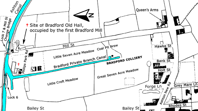
Bradford pit once stood there.
black mamba said:The area where the Townley is has always been Beswick ...... the ground itself is in Bradford.
Lower Openshaw comes into play as you approach Aston Old Road.
Your right Maryds was the.Bradford labour club and the pub across the road was called the crossroads had a huge picture of spaghetti junction in the bar it's Deffo Bradfordblack mamba said:I was born and raised around there in the late fifties/sixties ....
it's Bradford ....
Bradford pit once stood there.
In the sixties there once stood a cinema across the road from the ground site with a Bradford address ...... and i'm pretty sure that Mary D's was once known as 'Bradford Labour club'.
charliebigspuds said:if you go down Mercer way then you end up in bradford but if you come out of the ss and cross the road I think you're in Beswick, I'm sure the barstaff in the townley have polo shirts on with the townley Beswick embroidered on 'em. I actually thought that area was openshaw
The area where the Townley is has always been Beswick ...... the ground itself is in Bradford.
Lower Openshaw comes into play as you approach the Ashton Old Road area.